To measure a roof from satellite free, utilize online tools such as Google Earth or satellite imaging services. These platforms offer measurement features for aerial property assessment.
Exploring the possibilities of measuring a roof from the comfort of your computer has never been easier, thanks to advancements in satellite imagery. Whether you’re a homeowner preparing for renovations or a roofing contractor estimating materials, satellite-based measurements can be an invaluable resource.
These services often come equipped with user-friendly interfaces that allow you to outline your roof’s perimeter and automatically calculate the area. This method doesn’t only save time but also mitigates the risks associated with physically climbing onto a roof for measurements. Opting for free satellite measurement tools ensures a cost-effective solution while still providing a reasonable accuracy level for preliminary assessments and planning. Keep in mind, professional on-site evaluations are recommended for detailed and precise measurements before actual roofing work begins.
Essentials For Measuring A Roof Remotely
Measuring a roof has traditionally required physical presence and manual labor, but advances in technology have paved the way for accurate remote measurement options. By leveraging sophisticated satellite imaging and Geographic Information System (GIS) technology, anyone can now obtain precise roof measurements without ever leaving the ground. In this section, we’ll explore the essentials of measuring a roof remotely so you can tap into the full potential of this innovation.
Understanding The Technology Behind Satellite Imaging
Satellite imaging technology is a game-changer for the roofing industry. It uses earth-observing satellites equipped with sensors to capture high-resolution images of the earth’s surface. This advancement allows detailed scrutiny of roofing structures from above. When it comes to remote roof measurement, these images provide vital data that software algorithms can analyze to generate roof dimensions accurately.
- High-resolution imagery: Ensures clear views of roof details for precise measurements.
- 3D modeling: Offers an in-depth look at roof slopes, ridges, and valleys.
- Multi-temporal analysis: Allows tracking changes over time, essential for roof life-span assessments.
The Role Of Gis Systems In Roof Measurement
GIS systems are at the heart of refining data collected through satellite imaging. A Geographic Information System (GIS) harnesses geospatial data, transforming it into actionable insights. In the context of roof measurement, GIS systems offer several key functionalities:
- Reliable data layering for enhanced precision in measurements.
- Spatial analysis tools to identify roofing features and boundaries.
- Integration of various data sources for a comprehensive roof profile.
The marriage of GIS with satellite data is seamless, allowing for refined and accurate remote roof assessment.
Benefits Of Using Satellite Data For Roof Measurement
The transition from manual to satellite-based roof measurements brings a host of benefits that are transforming the industry:
| Benefit | Details |
|---|---|
| Safety | Eliminates the risks associated with physical roof inspections. |
| Efficiency | Significantly reduces the time needed for roof measurement. |
| Cost-Effectiveness | Minimizes the expenses of labor and manual measurement tools. |
| Accessibility | Allows measurements in inaccessible areas without issues. |
| Consistency | Ensures standardized measurement practices for higher accuracy. |
Embracing satellite technology for roof measurement eliminates the constraints of traditional methods, transforming practices for professionals and homeowners alike. As the technology evolves, the efficiency, safety, and accuracy of remote roof measurements will only enhance, solidifying its position as an industry standard.
Measure Roof From Satellite Free Platforms
Welcome to the world of advancements in satellite imagery and measurement technology, where obtaining precise dimensions of a roof has never been easier. ‘Measure Roof from Satellite Free Platforms’ offer a revolutionary way for homeowners, contractors, and real estate professionals to gain accurate roof measurements without the need for physical inspections on ladders or expensive equipment. Let’s delve into how one can leverage these free services to measure roofs with the click of a button.
Identifying Free Satellite Measurement Service Providers
There are a number of reputable free satellite measurement service providers available online. These platforms utilize high-resolution satellite imagery to help users remotely measure their roofs. Key providers to look for include:
- Google Earth – Offers tools to outline roofs and calculate areas using its vast image database.
- GIS services – Various Geographic Information System platforms provide tools for roof measurement.
- Specialized apps – Some apps use satellite and aerial imagery for DIY measurements.
Comparison Of Free Vs. Paid Tools
| Criteria | Free Tools | Paid Tools |
|---|---|---|
| Cost | No cost | Subscription or per-report fee |
| Features | Basic measurement tools | Advanced analytics, additional data layers |
| Accuracy | Generally lower accuracy | High precision measurements |
| Support | Limited or no user support | Professional support and consultancy |
| Data Accessibility | Publicly accessible data | More extensive databases, often proprietary |
For basic needs, free tools offer a solid starting point. However, paid tools provide enhanced services for those requiring greater detail and support.
Accuracy And Limitations Of Free Satellite Roof Measurements
While the convenience of free satellite roof measurements is undeniable, it’s crucial to consider the accuracy and limitations inherent in these services. Among the factors affecting accuracy are:
- Image resolution – Lower in free platforms as compared to high-resolution images used in paid tools.
- Data currency – Free platforms might have outdated images affecting recent changes unaccounted for.
- 3D modeling – Paid services have advanced 3D tools to calculate slopes and angles, often not available in free versions.
Understanding these limitations can help set realistic expectations when using free satellite measurement services for assessing roof sizes.
Step-by-step Roof Measurement Guide
Welcome to the Step-by-Step Roof Measurement Guide. Measuring a roof has never been easier thanks to the advancements in satellite technology. Whether you’re a homeowner looking to estimate the cost of a new roof or a contractor preparing an accurate quote for a client, this guide will walk you through the free satellite roof measurement process. Keep reading to get precise measurements without ever stepping on a ladder.
How To Access Satellite Imaging For Measurements
Gaining access to high-quality satellite images for roof measurement is straightforward. Follow these steps:
- Identify a reputable free satellite measurement service. Options include websites and apps like Google Earth, which provides clear satellite photos to the public at no cost.
- Navigate to the service’s website or download the app.
- Type in the address of the property and zoom in until you have a clear view of the roof.
- Take advantage of the measurement tools provided by the service. These may be in the form of a built-in ruler or an area calculator.
Tips On Ensuring Accurate Roof Dimensions
To guarantee precise roof dimensions, consider these tips:
- Measure all areas of the roof, including dormers, extensions, and garages.
- Use the zoom function to get a close-up view of the roof edges for more exact measurements.
- Verify the scaling provided by the satellite service. If available, use known measurements such as the width of a driveway as a reference.
- Take multiple measurements to ensure consistency. Repeat if necessary.
- Record measurements promptly to prevent any oversight or error.
Troubleshooting Common Issues With Satellite Measurements
Sometimes, measuring a roof using satellite images can present challenges. Here’s how to overcome them:
- For obstructed views caused by tree cover or shadows, try accessing different time stamps on the imagery to find a clearer view.
- Deal with low-resolution images by comparing multiple satellite services to find the clearest satellite imagery.
- Distortion at the edges of satellite photos can affect measurements. Focus on the center of the image where distortion is minimized.
- Calibrate roof slope angles by using third-party applications or tools specifically designed for this purpose.

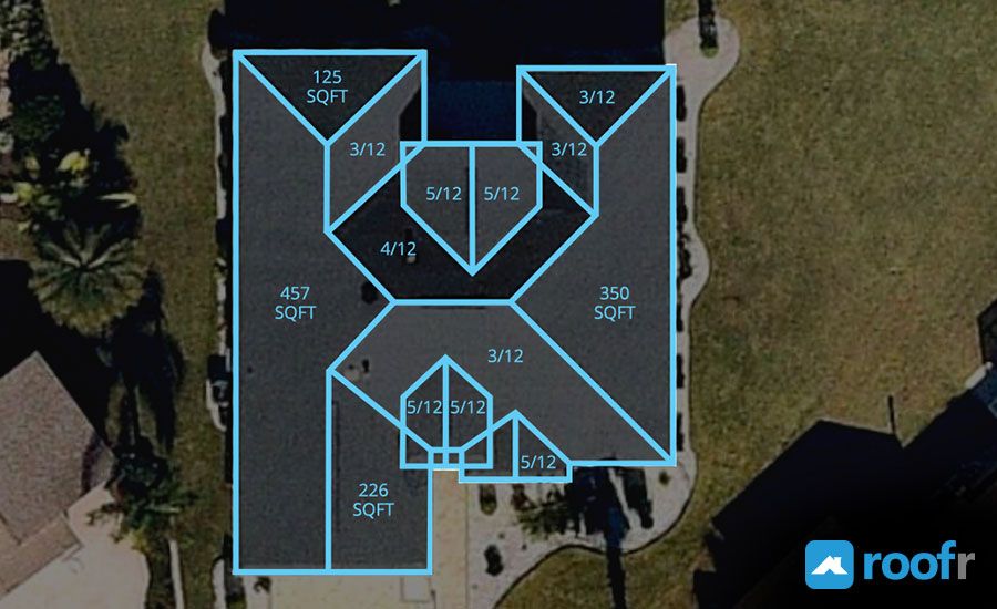
Credit: skyroofmeasure.com
Maximizing Roof Measurement Accuracy
When it comes to home improvement, understanding the precise measurements of your roof is pivotal for planning and executing roofing projects. With the advent of technology, measuring a roof from satellite imagery has become a go-to method for homeowners and contractors alike. To maximize roof measurement accuracy, it is crucial to employ a variety of techniques that enhance the precision of these estimates. In the following sections, we delve into how enhanced images, cross-referencing data, and AI technology can contribute to achieving more accurate roof measurements.
Enhancing Images For Better Clarity
Sharp, clear satellite images are fundamental for accurate roof measurements. Image enhancement is a critical step that involves:
- Adjusting brightness and contrast to reveal subtle roof features
- Using high-resolution images to minimize the room for error
- Applying filters and advanced editing techniques to emphasize roof edges
These improvements can significantly reduce ambiguities, leading to measurements that roofing professionals can rely on for creating precise estimates and plans.
Cross-referencing Satellite Data With Other Sources
To guarantee accuracy, combining satellite measurements with additional data sources is a powerful strategy. Techniques include:
- Comparing satellite measurements with blueprints or existing building plans
- Validating data against recent on-site inspections or drone imagery
- Cross-checking with various satellite providers to ensure consistency in data
This multi-source approach helps identify any discrepancies and provides a comprehensive view of the roof dimensions, minimizing the risk of inaccurate measurements.
Incorporating Ai For Improved Measurement Precision
Artificial Intelligence (AI) is revolutionizing the way roof measurements are performed. Key benefits of AI include:
- Automated analysis of complex roof structures
- Ability to learn and improve from each measurement
- Speed and efficiency in processing large volumes of satellite data
By harnessing the power of AI, measurement precision reaches new heights, ensuring that homeowners and contractors receive the most accurate, reliable roofing data available.
Practical Applications And Uses
Practical Applications and Uses of satellite imagery have revolutionized various industries, and roof measurement is one such area where this technology shines. Gone are the days of manual tapes and ladders; the advent of accurate satellite roof measurement tools has streamlined the process significantly. These tools are not only efficient but also offer safety benefits by reducing the need for physical roof inspections.
Applications For Homeowners And Contractors
Homeowners and contractors alike benefit immensely from the use of satellite roof measurement services. For homeowners, this technology simplifies the estimation process for roof repairs or replacements. They can obtain detailed roof measurements, which are essential for an accurate material list, thus preventing over or under-ordering—a common issue with manual measurements.
Contractors, on the other hand, use these measurements to enhance their workflow and reduce preparation time. Accurate satellite measurements allow for precise quotes and can improve the efficiency of labor allocation and roofing material management. Below are some of the key advantages:
- Time savings: Eliminates the need for on-site measurements.
- Cost-effectiveness: Reduces the costs of manual measurement and potential errors.
- Safety: Minimizes the risk of falls or accidents associated with rooftop assessments.
- Convenience: Enables remote assessment of potential projects.
Case Studies Showcasing Successful Measurements
Case studies from across the globe illustrate the success of satellite roof measurements in both residential and commercial projects. One notable example is a roofing company that transitioned to satellite measurements and witnessed a 30% reduction in assessment times and a 20% decrease in overall project costs.
| Measurement Parameter | Before Satellite Tech | After Satellite Tech |
|---|---|---|
| Time Spent | Several hours | Under an hour |
| Cost Accuracy | ±10% variance | ±2% variance |
| Safety Incidents | Occasional | Significantly reduced |
Future Developments In Satellite Roof Measuring Technology
A glimpse into the future of satellite roof measuring technology reveals an exciting trajectory. Anticipated developments include higher-resolution imagery and more advanced algorithms capable of detecting even the minutest features for ultra-precise measurements. Innovations like real-time data processing and enhanced integration with roofing software systems are on the horizon.
Emerging technologies such as artificial intelligence (AI) and machine learning are expected to further automate the measurement process, improving accuracy and reducing the time taken to analyze roofs. Drones might also be paired with satellite imagery to verify the data and provide additional perspectives on hard-to-access rooftops.
The continuous evolution of this technology signifies a transformative shift in the roofing industry, offering robust solutions that ensure efficiency, safety, and cost-effectiveness for all parties involved.
Frequently Asked Questions For Measure Roof From Satellite Free
Can You Measure Your Roof Using Satellites?
Yes, you can measure a roof from satellite imagery. Specialized online tools utilize high-resolution satellite photos to calculate roof dimensions. This method is effective for getting preliminary measurements without physical roof access.
What Free Tools Are Available For Satellite Roof Measuring?
Several free tools, such as Google Earth, offer basic features for measuring roofs from satellite images. Users can use the polygon tool to trace and estimate the roof area. However, accuracy may vary based on image resolution.
Is Satellite Roof Measurement Accurate?
Satellite roof measurements can be quite precise, although accuracy may be impacted by factors such as image resolution, angle, and date. For critical projects, it’s advisable to cross-verify with ground measurements.
How Do I Measure My Roof Pitch From A Satellite Image?
Measuring roof pitch from a satellite image directly isn’t possible. However, by calculating the roof’s rise and run using additional tools or apps designed for pitch estimation, and cross-referencing with the satellite measurements, one can estimate the pitch indirectly.
Conclusion
Measuring your roof has never been easier, thanks to free satellite imagery tools. With accuracy and convenience at your fingertips, embracing this technology can save time and money. Remember, always double-check with professionals for intricate projects. Ready to tackle your next roofing task?
Satellite measurements are a click away.